


IGNrando' – France hiking maps
Descrizione di IGNrando' – France hiking maps
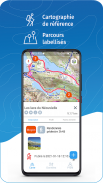
IGNrando’ è una piattaforma collaborativa per la condivisione di percorsi e punti di interesse (POI) relativi alle attività all'aperto in Francia.
RICCA OFFERTA DI DATI
• Decine di migliaia di percorsi e POI in tutta la Francia metropolitana e d'oltremare
• Scegli l'attività, il livello di difficoltà e la lunghezza del percorso per trovare percorsi intorno a te o vicino a qualsiasi altro luogo
• Scaricare o contrassegnare come preferiti i percorsi oi POI desiderati
MAPPE E LIVELLI IN ACCESSO GRATUITO (con connessione internet)
• Piano IGN: la mappa più aggiornata, adatta a tutte le attività
• Foto aeree (IGN)
• OpenStreetMap Outdoors: mappa del mondo con percorsi escursionistici e curve di livello
• OpenCycleMap: mappa del mondo con percorsi ciclabili e curve di livello
∙ Mappa IGN della Spagna
∙ Carta Swisstopo
∙ Mappa della copertura della rete mobile delle chiamate di emergenza (112) per la Francia
∙ OpenSnowMap
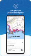
GUIDA GPS LUNGO I PERCORSI
• Visualizza i tuoi progressi sul grafico dell'altitudine
• Ricevi un avviso se esci dal percorso
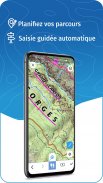
TRACCIATURA GPS E CREAZIONE DATI
• Registra i tuoi percorsi con il tracciamento GPS
• Crea rapidamente percorsi sul dispositivo con lo strumento di calcolo del percorso automatico che segue strade e percorsi (solo online, con abbonamento)
• Creare punti di interesse
• Invia i tuoi percorsi a
ignrando.fr
per il backup o per pubblicarli
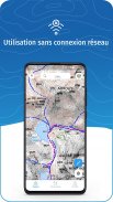
UTILIZZO OFFLINE
• Il GPS continua a funzionare anche senza internet: vedi la tua posizione sulla mappa, usa la guida GPS e registra i percorsi
• Percorsi scaricati: descrizioni, foto e guida rimangono accessibili
• Mappe scaricate (con abbonamento)
Suggerimento utile: l'attivazione della modalità aereo o la disattivazione dei dati mobili migliora la durata della batteria, senza influire sui servizi di localizzazione (GPS)
ABBONAMENTO IGN MAPS
• Creare percorsi con percorsi pedonali e veicolari
• Visualizza e scarica le seguenti mappe e livelli:
∙ Tutte le mappe della versione gratuita
∙ Mappe IGN (varie scale)
∙ Mappe topografiche IGN 1:25k (Top25): le famose carte topografiche francesi disponibili a tutti i livelli di zoom
∙ Mappe IGN del 1950
∙ Mappe militari (1820-1866)
∙ Carte aeronautiche ICAO
∙ Mappe di copertura degli operatori di rete mobile francesi
∙ Pendenze > 30° (utile per attività invernali)
∙ Strato particelle catastali
∙ Rete DFCI (rete antincendio boschiva)
• Aree soggette a divieto di volo dei droni
∙ Livello Strade e sentieri (disponibile solo con foto aeree)
Abbonamento al Play Store
• Collegato all'account Google
• Rinnovo automatico salvo disdetta almeno 24 ore prima della fine del periodo in corso
• Il rinnovo automatico può essere disattivato dopo l'acquisto
Abbonamento negozio Ubicarta
• Collegato al tuo account Ubicarta
• Acquista e gestisci il tuo abbonamento su ignandoapp.ubicarta.com
• Può essere utilizzato su 3 dispositivi contemporaneamente (Android e iOS)
Utilizza una scheda SD per archiviare i tuoi dati
Spazio libero sul tuo dispositivo.
——————————————————————
L'app utilizza la connessione di rete per eseguire lo streaming di mappe o per scaricare contenuti o mappe. Potrebbero essere applicate le tariffe del corriere.
L'app utilizza la posizione del tuo dispositivo per visualizzarla sulla mappa, registrare tracce e condividerla con i tuoi amici tramite la funzione di condivisione della posizione.
Ho idee per migliorare l'app IGNrando
Scrivici su:
ignrando@ubicarta.com
IGNrando' – France hiking maps - Versione 1.97.13
(18-04-2025)IGNrando' – France hiking maps - Informazioni APK
Versione APK: 1.97.13Pacchetto: ubicarta.ignrandoUltima versione di IGNrando' – France hiking maps
Altre versioni


App nella stessa categoria

Potrebbe piacerti anche...


